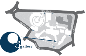
Tues-Fri 12-5pm, Sat&Sun 11am – 4pm, closed Mondays.
The O3 Gallery is open during exhibitions only (please
check dates) and may be closed for a short period in between
whilst we install a new show. Opening times may be subject
to change, please ring 01865 246131 for up-to-date information.
|
From
The East (From London M40)
Leave the M40 at Junction 8 to join the A40 (Oxford).
Continue until you get to the Green Road Roundabout,
taking the first exit onto the Ring Road (A4142), remain
on the Ring Road, continuing straight over the next two
roundabouts. At the third roundabout take the second
exit onto the Abingdon Road (A4144), towards the City
Centre. Once over Folly Bridge take the first left onto
Thames Street, follow the road around continuing into
Oxpens Road, passing the Ice Rink and Oxford & Cherwell
College. Follow the road around (bearing right) and into
Hollybush Row and take the second right into St Thomas
Street. Follow this road bearing left and into Tidmarsh
Lane, Oxford Castle is situated on the right.
From The South (From Dorchester A423)
Continue on the A423 (towards Littlemore) at the first roundabout
take the first exit joining the Ring Road (A4142). Carry on until the
next roundabout and take the second exit onto the Abingdon Road
(A4144), towards the City Centre. Once over Folly Bridge take the
first left onto Thames Street, follow the road around continuing onto
Oxpens Road, passing the Ice Rink and Oxford & Cherwell College.
Follow the road around (bearing right) and onto Hollybush Row and
take the second right onto St Thomas Street. Follow this road bearing
left and onto Tidmarsh Lane, Oxford Castle is situated on the right.
(From Abingdon
A34)
Continue on the A34 towards South Hinksey, at the first roundabout
take the third exit onto the A4142 Ring Road. At the next roundabout
take the first exit onto the Abingdon Road (A4144), towards the City
Centre. Once over Folly Bridge take the first left onto Thames Street,
follow the road around continuing into Oxpens Road, passing the
Ice Rink and Oxford & Cherwell College. Follow the road around
(bearing right) and into Hollybush Row and take the second right
onto St Thomas Street. Follow this road bearing left and onto Tidmarsh
Lane, Oxford Castle is situated on the right.
From The West
At the junction of the A420 and the A34, take the Botley Road into
Oxford City Centre. You will pass the central train station on your
left after approximately 2 miles. After the traffic lights outside the
station, approach the next traffic lights which are 50 yards further
on, get in right hand lane. You are now directly opposite Smollensky’s.
Turn right and get in left hand lane. Take the first left down Park End
Street. Proceed towards the end of Park End Street (you will see an
open car park on your left which is a short walk from the Castle)
and turn right up New Road. The Castle Development is on your
right hand side after approximately 0.5 of a mile.
Parking is available as previously indicated at the end of Park End
Street or in the Westgate Centre which can be reached by driving
past the Castle and following the road around to the entrance of
the car park which you will drive under shortly after passing the
Castle.
From The North
From the M40, take Junction 9 to the A34 following signs for Oxford
City Centre. At the Peartree Roundabout (after approximately 4
miles), follow signs to Oxford City Centre. After Peartree Roundabout
(this is the roundabout with services, Holiday Inn and Travel Lodge
on), turn left up approximately 0.5 mile dual carriageway. Take the
right hand lane and proceed around the roundabout, making sure to
cross to middle lane which will take you to Oxford City Centre via
Woodstock Road.
After approximately 3 miles, keeping a straight line, you will
come to traffic lights at Martyr’s Memorial (to the right hand side you will
see The Randolph Hotel). Turn right here up Beaumont Street. Proceed
to the end of the road and take the left turn towards Hythe Bridge
Street.
Having gone over the small bridge, get in left hand lane and turn
left and then left again (back on yourself) into Park End Street.
Proceed towards the end of Park End Street (you will see an open car
park on your left which is a short walk from the Castle) and turn right
up New Road. The Castle Development is on your right hand side after
approximately 0.5 of a mile.
Parking is available as previously indicated at the end of Park End
Street or in the Westgate Centre which can be reached by driving past
the Castle and following the road around to the entrance of the car
park which you will drive under shortly after passing the Castle.
By Train
Oxford Train Station is located approximately 1 mile from Oxford
Castle. Leave the station and head for the main road, turning left at
the main traffic lights around the Said Business School – large building
in front of you, across from bus and taxi stops, as you walk out of the
station. Keeping the Said on your left, walk up Hythe Bridge Street
turning right in front of Café Coco. Turn immediately left down
Park End Street.
Proceed towards the end of Park End Street and turn right up New
Road. The Castle Development is on your right hand side after
approximately 0.5 of a mile.
By Bus
Gloucester Green bus station is located in the heart of Oxford City
Centre in George Street. Once on George Street, turn right and then
immediately left and bear left around the corner into New Road.
Oxford Castle is located on the right hand side after approximately
0.5 mile.
BY PLANE
Heathrow Airport 90 minutes
Gatwick Airport 120 minutes
Luton Airport 90 minutes
Coventry Airport 60 minutes
Oxford Airport 20 minutes
|